
In a city where freeways carve up the landscape like veins of concrete, and the car reigns supreme, the idea of strolling from a luxury shopping district straight into one of America’s largest urban parks might sound like a fever dream. But in Houston, where reinvention is as much a tradition as barbecue, such visions are becoming reality.
I spoke with Clark Martinson, the Public Spaces Director at Uptown Houston, about a project that’s been percolating for over a decade: the Uptown Memorial Park Trail and Bridge.
Formally dubbed the West Loop Shared Use Pathway & Bayou Bridge through its federal grant, this isn’t just a pedestrian link, it’s a bold stitch in the urban fabric, for the first time connecting the gleaming towers of Uptown with the wild expanse of Memorial Park.
Martinson walked me through the details from the project’s starting point at the intersection of Post Oak Boulevard and Uptown Park Boulevard, a corner that’s equal parts high fashion and high traffic. As of mid-2025, with construction slated to begin in the fourth quarter and wrap by early 2027, the $21 million endeavor promises to transform how Houstonians, and visitors alike, navigate their city: on foot, by bike, and amid the rustle of leaves rather than the roar of engines.
Uptown Houston’s Urban Transformation: From Concrete to Canopy
Uptown Houston has long been a proving ground for ambitious urban experiments. Martinson recalls how long before the district was formed, the are dodged a bullet in the form of a TxDOT plan that would have bulldozed the creation of IH-610 right through Post Oak Boulevard, threatening to turn one of the city’s premier corridors into another anonymous strip of asphalt. Instead, Uptown recently completed a full reconstruction of the boulevard, introducing dedicated bus lanes, wider sidewalks, and a canopy of trees that softened the superblocks typical of West Houston’s sprawl.
This spirit of reinvention has fueled a wave of mixed-use developments, weaving retail, residential, and office spaces into a more walkable tapestry. Projects like BLVD Place, anchored by Whole Foods, have added over 124,000 square feet of retail and nearly 100,000 square feet of office space, while nearby high-rises such as Aspire Post Oak have contributed hundreds of luxury housing units.
In total, Uptown’s urban core now boasts some 6.3 million square feet of retail, 22,000 residential units, and 27 million square feet of office space, figures that reflect a district evolving from car-dependent isolation toward something more human-scaled and interconnected.
Uptown’s fingerprints are already on Memorial Park’s centennial master plan, including the serene Eastern Glades and the dramatic Kinder Land Bridge and Prairie, where the Uptown skyline serves as a distant, shimmering counterpoint to the park’s natural undulations.
The new trail and bridge? It’s the logical next chapter, Martinson says, a gateway that honors the park’s history while propelling Houston toward a greener, more equitable future.
How the Uptown Memorial Park Trail Will Reshape Mobility and Green Space
The journey begins unassumingly, behind the Uptown Park shopping center, where a surface parking lot is being repurposed into a shaded green corridor. Here, ingenuity meets necessity: massive underground culverts will handle stormwater detention, turning potential flood risks into resilient infrastructure. Retailers in the center, styled like an Italian villa, may see their back entrances activated as trail-facing facades, echoing successful adaptations at places like M-K-T Heights or Heights Mercantile.

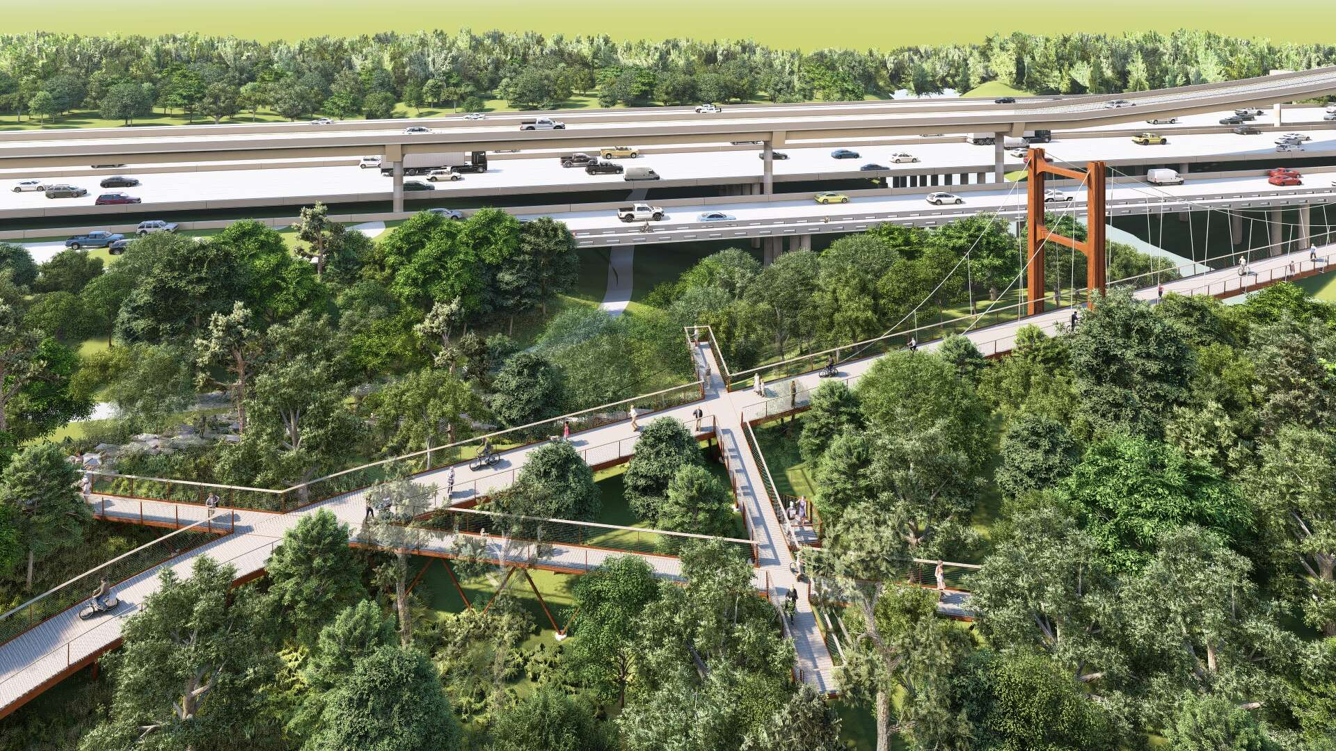
Safety is paramount in a city notorious for its driving habits. At Uptown Park Boulevard, where vehicles currently barrel through a pedestrian crosswalk to access the freeway frontage road, the design calls for abandoning the hazardous setup altogether.
In its place: a mid-block crossing with modern sightlines, protective elements, and jersey barriers to shield trail users from traffic. The trail parallels the West Loop frontage road for only a short stretch, minimized at the insistence of the Memorial Park Standards Committee, which demanded that any invitation into the park feel like an escape, not an endurance test.
Then comes the drama. The path ascends to a 350-foot suspension bridge over Buffalo Bayou, a cost-effective, off-the-shelf design that spares the extravagance of custom engineering. But the real enchantment follows: to navigate the 500-year floodplain, the trail extends another 300 feet as an elevated, 14-foot-wide boardwalk, hovering nearly 10 feet above the ground.
This canopy walk, Martinson explains, immerses users in the treetops, offering views that rival the best of Houston’s hidden groves. SWA Group, the landscape architects behind local gems like the Jackson Hill, Rosemont, and Mason Park bridges, as well as the birdwatcher’s paradise of High Island’s canopy walk on Galveston Bay, leads the design, ensuring the structure blends seamlessly with its surroundings.
Once in Memorial Park, the trail traces echoes of the past: an old road through the archery range, a loop near a 1920s-era Boy Scout camp site, and a timber bridge over a ravine with an overlook for bayou vistas. Nearby enhancements, like the Southern Arc Trail, the I-10 TIP Project Bridge, and the under-construction Memorial Groves, amplify the connectivity, turning isolated pockets into a cohesive network.
Connecting Houston’s Active Transportation Network Through Memorial Park
This isn’t an island of improvement, it’s a vital thread in Houston’s active transportation web. The trail ties into Memorial Park’s internal paths, including the 10-foot-wide Commuter Trail, decomposed granite loops on Memorial Drive, and asphalt circuits on Woodway. It links to METRO’s shared-use path on North Post Oak Road, a 14-foot pedestrian bridge over I-10, the Northwest Transit Center, and onward to the Spring Branch network, Timbergrove, and the White Oak Bayou Trail.
Imagine a car-free odyssey from Spring Branch through Uptown and Memorial Park to the Heights, a route that could redefine daily commutes and weekend escapes.
For visitors, the impact is profound. Luxury hotels like The Houstonian and The Post Oak Hotel, along with thousands of rooms in the area, will gain direct access to Memorial Park, one of the nation’s largest urban green spaces. The Galleria, a magnet for shoppers nationwide, becomes more approachable without a car.
In a city where tourists often stick to hermetically sealed hotels and malls, this connection invites exploration on foot or bike, showcasing Houston’s underrated walkability and natural allure.
Funding and Infrastructure Challenges for the San Felipe Trail Extension
Yet, as Martinson notes, the vision extends further, and so do the challenges. A natural extension of this trail is the San Felipe to Memorial Park connection, originally planned to run through CenterPoint and UPRR corridors. However:
- The project cost has ballooned to $20 million
- A $12 million local match remains unfunded (only $8M has been secured via grants)
- CenterPoint Energy has conditioned use of their easement on upgrading transmission infrastructure—adding $8M to project costs
- The City of Houston is managing the project, and as of May 2024, the final decision rests with the Whitmire administration
These corridors were built to serve the public, but many are controlled by private interests. And too often, those interests stand in the way of progress. CenterPoint Energy’s insistence on bundling costly infrastructure upgrades into a trail easement deal is just the latest example. The result? Delays, inflated costs, and a public left waiting.
Clark Martinson points out the larger pattern: when critical transportation projects get caught in the friction between public need and private control, it’s Houstonians who pay the price. From Fifth Ward’s contamination battles to decades of deferred maintenance across utility corridors, the burden isn’t shared equally, it’s shouldered by the communities that can least afford it.
And yet, this project shows what’s possible when institutions work together. A broad coalition, BikeHouston, the Houston Parks Board, METRO, the Astros Golf Foundation, Connect Community, Memorial Park Conservancy, the Arboretum, TxDOT, and tireless advocates like Regina Garcia and Capt. Joe Hood, has pushed this vision forward. But scaling that momentum means holding power to account. Public good can’t be held hostage by private inaction.
What This Bridge Means for the Future of Walkable, Equitable Houston
In the end, this bridge is more than steel and suspension, it’s a metaphor for Houston’s potential. A city built for cars is inching toward one designed for people, where transportation, resilience, and public space intertwine. When complete, it could link hotel lobbies to forest trails, office towers to bayou overlooks, fostering healthier, more connected lives.
But such transformations don’t happen overnight; they unfold over years, even generations. As Martinson urges, the time to act is now. Demand leadership that sees projects like this not as luxuries, but as necessities, for equity, for the environment, for the Houston our children will inherit. In a place as sprawling and spirited as this, bridging the divide starts with a single step.


Leave a Reply